


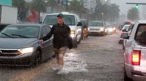
Severe rainstorms caused extensive flooding in multiple communities in South Florida, including Miami and Fort Lauderdale, on Wednesday. The heavy downpours led the state’s governor to declare a state of emergency and left drivers stranded throughout the region.
The National Weather Service issued flood warnings for parts of Broward, Miami-Dade, Collier, and Hendry counties until Thursday morning, emphasizing the ongoing risk of life-threatening flooding. Flood watches were also extended for Miami and Fort Lauderdale until Friday evening.
The weather service urged residents to stay off the roads due to the high water levels, stalled cars, and the expectation of further rainfall. Videos shared on social media depicted flooded streets, parking decks, and vehicles submerged up to their windows.
Video footage from Miami showed cars completely submerged under water due to flooding. This is the second day in a row that the Miami area has experienced flooding issues. On Tuesday, storms brought heavy rain, causing streets to flood with 2 to 5 inches of water.
In Hallandale Beach, one man was seen kayaking among the flooded streets. Officials advised residents to stay indoors and avoid driving or walking through the high waters.
During the storm, a family in Hallandale Beach lost their son. Fortunately, local police were able to locate the young boy and reunite him with his family.

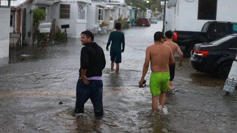
One woman shared her experience of being stuck in her car for five hours on Hallandale Beach Boulevard and US Route 1 due to the flooding. Traffic lights were out at several intersections and there were already abandoned cars. A Hollywood resident, Kait Madrigal, expressed her shock at the unprecedented situation.
A recent storm system brought heavy rainfall and an EF1 tornado to Hobe Sound in Martin County, Florida. This was confirmed by a damage survey conducted by the National Weather Service. As a result of the severe weather, Florida Governor Ron DeSantis declared a state of emergency for Broward, Collier, Lee, Miami-Dade, and Sarasota counties. The governor cited the impact of the heavy rain and floods on critical infrastructure such as interstates, roadways, schools, and airports. In Broward County, the severe weather also led to the postponement of the demolition of the Marjory Stoneman Douglas High School building, where a tragic shooting took place in 2018. Additionally, due to localized flooding caused by the heavy rain, the Collier County School District announced the closure of summer school and child care programs on Thursday.
According to the district’s website, flooding at bus stops and on streets is causing dangerous conditions for transportation of students and staff.
Fort Lauderdale Mayor Dean Trantalis has declared a local state of emergency due to a month’s worth of rain falling in just one day. The excessive rainfall has led to flooding and high water on roads throughout the city. Emergency management staff are using high water vehicles and vacuum trucks to address the situation.
Mayor Trantalis is urging residents to stay off the streets until the standing water is pumped out. The city recorded approximately 9.58 inches of rain on Wednesday, making it the eighth wettest day in Fort Lauderdale’s history, according to the National Weather Service.
“The early afternoon saw a rush of people leaving work early to beat the rain,” Trantalis told CNN. “The streets were packed with cars instead of being flooded with water.”
The preliminary rainfall total exceeded Fort Lauderdale’s average June rainfall of 9.55 inches, indicating that the area received more than a month’s worth of rain in just one day. However, this total is still lower than the record-breaking rainfall in April 2023, which caused severe flooding with around 2 feet of rain in a 24-hour period.
Over the past 48 hours, heavy rainfall accumulated to about 12.8 inches, making it the ninth wettest two-day period in the city’s history.
The severe weather conditions resulted in over 600 flight cancellations and delays at two of the region’s main airports. Miami International Airport experienced at least 334 canceled flights, while Fort Lauderdale-Hollywood International Airport had more than 287 cancellations.
As the world warms due to fossil fuel pollution, heavy rain events in Florida are becoming even more intense. Tropical moisture from the Caribbean is also contributing to the heavy downpours, flowing directly into South Florida along a front that stretches across the state.
Over the next few days, a broad area of storms will continue to bring several more inches of rain to Florida. While the storms are not currently expected to develop into a tropical depression, the National Hurricane Center does give them a low chance of organizing as they move off the Southeast coast.
By Friday, parts of Florida could see double-digit rainfall totals, with some areas in southwest Florida possibly approaching 20 inches. The southwestern Gulf Coast, from Sarasota to Everglades National Park, faces the greatest risk of receiving 10 inches or more of rainfall.
Intense rain showers outside the highest risk areas may result in flash flooding, particularly in urban or poorly drained areas.
Flood watches are currently in place for over 8 million people in South Florida from Wednesday through at least Thursday night.
Moisture from the Gulf of Mexico continues to move over South Florida, leading the Weather Prediction Center to issue a level 2 out of 4 flood threat for Wednesday, Thursday, and Friday nights. Southeastern Florida, including Miami and Fort Lauderdale, is expected to receive an additional 3 to 6 inches of rainfall by Friday. In some areas of South Florida, rainfall totals could exceed a foot, which is equivalent to several months’ worth of rain.
As storms persistently dump heavy rain over the same region day after day, the flood risk will continue to escalate. This consistent rainfall will cause the overall rainfall accumulation to increase, saturate the soil, and cause local waterways to rise.
The silver lining in this situation is that the rain will provide much-needed relief to areas experiencing drought. According to the US Drought Monitor, half of Florida is currently facing abnormal dryness or drought conditions, with the worst drought centered in the area that will receive the heaviest rainfall.
The source of this abundant moisture can be attributed to a giant gyre, a large and disorganized area of showers and thunderstorms, that typically gathers over the Caribbean Sea and the southern Gulf of Mexico during this time of the year. This gyre rotates over Central America and its surrounding waters.
The broad rotation and ample moisture of the gyre can contribute to the formation of tropical systems in various regions, including the Caribbean, Gulf of Mexico, and even the eastern Pacific, provided that other necessary factors such as favorable upper-level winds and warm ocean water are present.
The gyre typically forms in late spring and early summer, which is why most tropical systems in June develop in the Gulf of Mexico or off the East Coast of the US.
According to meteorologist Jon Rizzo from the National Weather Service in Key West, Florida, despite warm water in the Caribbean and Gulf of Mexico, the presence of disruptive upper-level winds called wind shear prevents the formation of tropical systems in these areas.
The gyre, however, is increasing wet weather along the Gulf Coast, including Florida this week.
“The formation of the Central American gyre indicates that summer has arrived and the rainy season is about to start,” said Jon Rizzo, a meteorologist from the National Weather Service in Key West, Florida, in an interview with CNN.
In Florida, the months of June, July, August, and September are typically the rainiest. During this time, the region experiences frequent influxes of intense, tropical moisture, and the direct influence of tropical systems amplifies the amount of rainfall significantly.